1/13/2017, 2:08 pm
.
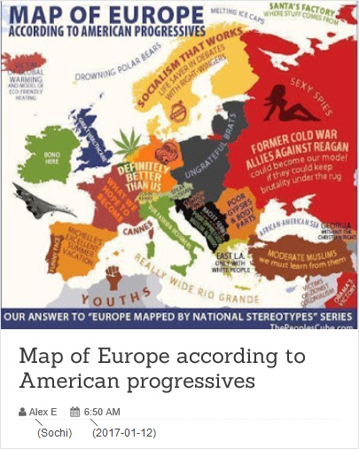
Everyone knows ‒ I mean here, in Yurop (where we are cultured, progressive people) ‒ that the Election of November 8th was a deplorable, faked and hacked, "victory" of the Hawk of Crude Hateful Populism over the Dove of Nuanced Hopeful Globalism-Internationalism.
Yet another drammmatic depiction of the result of Kremlin hackery combined with Trumpian chutzpah appeared recently :


That imagery, in full detail, appeared mid-December here, created by Alex Egoshin (appears to live in Sochi).
It delightfully augments Comrade Director's Glorious Math (There are 3,141 counties...).
~
Tech :
Maps were created using IDW (Inverse distance weighted) technique in ArcGIS, says Alex E.
(ArcGIS a software-tool, GIS = Geographic Information System).
IDW (not highly complex, but anyway hard Math) is an interpolation method.
Something like : on every polling place, put a smooth bell with (very) steep slopes and of height proportional to the number of (valid) ballots counted there. If two such bell-surfaces overlap (on the fringes), weld the fringes by some "averaging" into a smooth surface. That's it.
The whole area of America covered with a surface, and thousands upon thousands of bell-shaped spikes on it.
Now, to get the maps above :
For Trump, put a red bell-surface only on polling places where ≥51% ballots were "for Trump".
Same with Clinton : a blue bell, wherever ≥51% ballots were "for Clinton".
The resulting red surface (red hills, peaks, plateaus, gentle slopes, down to blots on "level zero" - lakes, seas, bays, ponds) is Terra Trumpia.
Same with the blue surface - Terra Clintonia. Turns out, an archipelago.
IDW in Xclopedias : (related to the Infogalactic/Everipedia/DuckDuckGo discussion started here)
Googling (pointedly) for "Inverse distance weighted", you get :
(other search engines will answer differently, of course)
Infogalactic : Geostatistics → IDW.
Everipedia : Multivariate interpolation → IDW.
DuckDuckGo : no idea (basically, points to WPedia).
Wikipedia : IDW.
All the three above present the same (pretty good) IDW-article.
BUT (scratching head...) :
Infogalactic can't render Math, Everipedia can't show pics, yet Wikipedia can both. hmmm...
(uh, don't get me wrong - not a pean for WPedia, just "the others" have more of growing pains ; WPedia stunk "since ever" in "politically relevant" corners ; prominent case : years-long "Kulturkampf" around "Climate Science".)
Everyone knows ‒ I mean here, in Yurop (where we are cultured, progressive people) ‒ that the Election of November 8th was a deplorable, faked and hacked, "victory" of the Hawk of Crude Hateful Populism over the Dove of Nuanced Hopeful Globalism-Internationalism.
Yet another drammmatic depiction of the result of Kremlin hackery combined with Trumpian chutzpah appeared recently :
That imagery, in full detail, appeared mid-December here, created by Alex Egoshin (appears to live in Sochi).
It delightfully augments Comrade Director's Glorious Math (There are 3,141 counties...).
~
Tech :
Maps were created using IDW (Inverse distance weighted) technique in ArcGIS, says Alex E.
(ArcGIS a software-tool, GIS = Geographic Information System).
IDW (not highly complex, but anyway hard Math) is an interpolation method.
Something like : on every polling place, put a smooth bell with (very) steep slopes and of height proportional to the number of (valid) ballots counted there. If two such bell-surfaces overlap (on the fringes), weld the fringes by some "averaging" into a smooth surface. That's it.
The whole area of America covered with a surface, and thousands upon thousands of bell-shaped spikes on it.
Now, to get the maps above :
For Trump, put a red bell-surface only on polling places where ≥51% ballots were "for Trump".
Same with Clinton : a blue bell, wherever ≥51% ballots were "for Clinton".
The resulting red surface (red hills, peaks, plateaus, gentle slopes, down to blots on "level zero" - lakes, seas, bays, ponds) is Terra Trumpia.
Same with the blue surface - Terra Clintonia. Turns out, an archipelago.
IDW in Xclopedias : (related to the Infogalactic/Everipedia/DuckDuckGo discussion started here)
Googling (pointedly) for "Inverse distance weighted", you get :
(other search engines will answer differently, of course)
Everipedia : Multivariate interpolation → IDW.
DuckDuckGo : no idea (basically, points to WPedia).
Wikipedia : IDW.
BUT (scratching head...) :
Infogalactic can't render Math, Everipedia can't show pics, yet Wikipedia can both. hmmm...
(uh, don't get me wrong - not a pean for WPedia, just "the others" have more of growing pains ; WPedia stunk "since ever" in "politically relevant" corners ; prominent case : years-long "Kulturkampf" around "Climate Science".)